Stage 5 – from San Gemini to Cesi
With your back to the main door of the Church of Saint Francis, take Via Casentino, going through the arch on the other side of the square and, at the end of the road, you will find a little square, Piazza Garibaldi. From here, walk downhill along Via delle Mura and go through the arch of the medieval gateway.
As soon you have gone through the gateway, walk downhill along Via San Giovanni on the left. At the end of the road turn left at the junction into Via del Sole, walking along the pavement on the left-hand side. At the next junction with the provincial road (Via Tuderte) walk along the bicycle lane on the right and follow it until you reach the San Gemini station.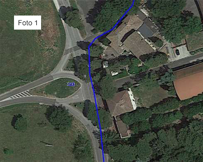 At the end of the bicycle lane, be careful as you cross the road. Continue on along Via Tiberina being careful as you cross the railway flyover. Continue on along the provincial road for 800 metres (be careful, as the road is wide but busy) until you reach a large crossroads.
Here, don’t take the road on the left, don’t go straight on and don’t take the first road on the right, but take the second road on the right, called Via Carsuae, after going past the large sign of the Antica Carsulae restaurant. See photo 1
Continue on for approximately 750 metres along Via Carsulae and, after passing a beautiful cottage on your left, walking slightly uphill, you will come to a crossroads with five roads. Take the second road on the left (the one with directions to the Bar and that has an open metal barrier).
It is a slightly uphill unpaved road and, after 200 metres, you will find the barred road with a pedestrian walkway. After going past the little bar on the right and the Carsulae Archaeological Park ticket office, which we strongly advise you to visit, (3.9 km from the departure point), continue on along the dirt road for 400 metres and walk through the underpass.
After going through the underpass and a small building on your right, turn left through the cark park (instead of exiting from the car park), take the path in front of you, between the lampposts, for about 10 metres and when you come to a very wide unpaved road, turn right and continue on uphill along this road for approximately 2.2 km until you get to a signpost (on the right) indicating “La Romita”.
Take the path and follow it for about 600 metres until you reach the Romita di Cesi hermitage (7.3 km from the departure point).
After your visit to the Romita di Cesi hermitage, continue walking, from the place you entered, turning right into a narrow road. After 100 metres, turn right onto a path with a little stone wall on the right-hand side. Continue on, keeping to the main path (do not make any detours) for 1.2 km until you reach some ruins that you will first find in front of you and then walk alongside them for a short stretch on the right.
Continue on for 150 metres (after passing a slight bend to the right) and take the path on the left (a yellow TAU makes it recognisable).
Continue on along the path for 100 metres until you reach a clearing.
Take the path that leads uphill through the clearing and then into the woods. Continue on for 500 metres after the clearing, until you come to an unpaved road. Turn right downhill into the unpaved road and, after 30 metres, take the path on the left, just before the slight bend to the right that follows on from the downhill unpaved road (be very careful here). Continue on for 200 metres until you come to another unpaved road running down from the mountains. Important!!! Take the path in front of you, without following the unpaved road either downhill or uphill.
Continue on for 700 metres, without making any detours, always following the path until you reach an old spring.
When you reach the spring, continue on around a bend to the right (do not take the uphill path).
Continue on for another 1000 metres without making any detours until you come to a tarmac road. After crossing the tarmac road, turn right downhill and continue on for 800 metres until you find the entrance to the village of Cesi on the left (the entrance is on a very narrow downhill bend to the right) in Via Angelo Cesi. Continue on for 150 metres in Via Angelo Cesi and, on the right, there are some steps (after going past a small square) that will take you to the parvis of the Church of Santa Maria Assunta.


