Stage 6 – from Cesi to Terni
Stage 6 - from Cesi to Terni
Final stage of the Walk of the Franciscan Protomartyrs, taking you mainly along tarmac roads.
Final leg. It takes place mostly on a flat road.
Highlights of the day are the Sanctuary of Santa Maria dell’Oro (St. Mary of the Gold) where St. Bernardino of Siena wanted to build the ancient Franciscan convent.
The Church of St. Antonio, also called “The Anthonian Protomartyrs’ Sanctuary”, is the final destination of our pilgrimage.
It enshrines the relics of our saints. Paintings by Piero Casentini adorn the altar.
- From: Cesi (Chiesa di Santa Maria Assunta)
- To: Terni (Chiesa di Sant'Antonio - Santuario dei Protomartiri Francescani)
- Distance: 17,16 Km
- Increase in altitude: + 173
- Loss of altitude: - 825
- Surface: tarmac
- Road Sign: yes
- Travel time: 5 hours
- Water sources: yes
- Resting areas: yes
- Degree of difficulty: Medium
With your back to the main door of the Church of Santa Maria Assunta, turn right into the narrow downhill road, Strada Santa Maria della Bottega. Continue on for approximately 100 metres until you come to Via Casella. Turn right and continue on for another 100 metres downhill, until you get to Via Bella Vista (you will see a Chemist’s shop opposite). Turn right, or in other words continue walking along on the right. Continue on for 250 metres (the road also is indicated as Viale Regina Elena). Turn left into the steep downhill road, Strada della Pittura, and continue on for approximately 300 metres (on the right after a sharp bend you can admire an ancient Roman wall made of large blocks of stone) and then take Strada di Condotto on the right and continue on for 400 metres until you come to the fork of Strada di Condotto. Take the road on the left (a gate on the right will confirm the direction) and continue on for 500 metres until you come to Strada di Mazzamorello and turn into it, to the left. Continue on along this road without, making any detours, for 1.5 km until you reach the Cesi Railway Station.
Go past the Cesi Railway Station, keeping it on your right, and continue on for 150 metres (on the pavement on the left of the road) until you come to the sign indicating Via Giovanni Ecchio on the right.Here, the entrance to Via Giovanni Ecchio is very wide and it leads us to a car park and, on the left, there is the real entrance to Via Giovanni Ecchio.
When you reach a crossroads with a small roundabout, take the second narrow road on the right, Via delle Cinque Strade, and continue on along this road for 1.1 km. Turn left into Strada di Santa Maria La Rocca for approximately 100 metres, then turn right and a little further on cross the dual carriageway flyover. Continue on along the slightly uphill road, turn left at the junction and turn right immediately into Strada di Palmetta. Continue on for approximately 1 km.
Just after the bend to the left, turn right after 50 metres into Via Colle dell’Oro and you will arrive at the Church of Colle dell’Oro (8.5 km from the departure point).
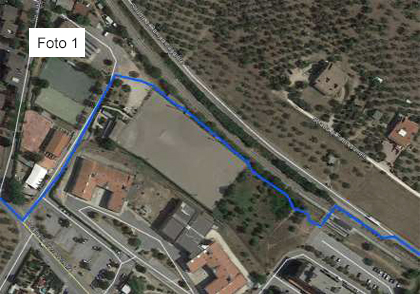
Leaving the Church square, turn left and after 30 meters turn left again and take the path with a high fence wall on the left. Follow it for 150 meters until you cross a dirt road, continue on the dirt road for 50 meters and turn left taking another dirt road.
Go straight on for 80 meters until you get to a wide path (the “paved road of the friars”) and follow the path for 650 meters until you get to the tarmac road going downhill; continue for 350 meters until you cross a wide tarmac road (Viale Ettore Proietti Divi) and take the pedestrian lane continuing until the pedestrian traffic light after 100 meters.
Cross the road using the traffic light and go straight entering the parking lot; here turn right and reach the stairs that allow you to take the overpass over the railway.
Go through the overpass (overpass over the railway) and go down the stairs. You are now in the entrance area of the train station. After the stairs turn right (follow the indications on the poles of the road signs) and then left using the pedestrian stripes until you arrive under the Great Press of green color.
Then turn left and follow the sidewalk of Viale Curio Dentato for 300 meters, then, on the right, the destination will appear: Church of Saint Anthony – Antonian Sanctuary of the Franciscan Protomartyrs
What you should know before departure
There are water fountains in Foligno: Bar del Cacciatore – Chiesa di San Giovanni Bosco – Chiesa di Santa Maria dell’Oro.
Remember to fill your water bottle with at least 1.5 litres of water in the summer.
During this stage, there are no places equipped for lunch, so you need to take a packed lunch to be eaten even at the Chiesa di San Giovanni Bosco or to Chiesa di Santa Maria dell’Oro.
We recommend that you have the maps of the trail with you.
Terni Municipal Police Tel. 0744 426000

Must-see
- Terni
- Basilica di San Valentino - Terni
- Chiesa di Sant’Antonio – Santuario dei Protomartiri - Terni
- Chiesa di San Francesco - Terni
- Chiesa di Santa Maria dell’Oro - Terni
- Cascata delle Marmore - Terni
- CAOS - Centro Arti Opificio Siri - Museo di Arte Contemporanea - Museo Archeologico - Spazi Culturali - Terni
- Cattedrale di Santa Maria Assunta (Duomo)
The Way of the Franciscan Proto-martyrs

Stage 6
From San Gemini to Cesi


